Ennal’s Pool lies in Cornwall’s china-clay country. The lake, cut ground, spoil, tanks, tracks and surviving structures all belong to that history.
Explore seven distinct historic maps and photographs in sequence. Features appear, shift and disappear; some still survive under the woodland. Select any image to open the original scan and examine it in detail.
1882 · first-edition Ordnance Survey
A wooded valley before the larger pit
The first-edition survey shows Chithan, numbered fields and a narrow, tree-marked valley before the later workings transformed this ground. A spring and a ford are explicitly labelled beside the western lane. Farther east are a three-foot footpath, a shaft, a boundary stone and a few small structures.
The spring, ford and valley are useful starting points for tracing the earlier drainage corridor. They are evidence of water in this landscape, though the exact alignment of a continuous stream still needs verifying.
Features to look for: Spring · ford · three-foot footpath · shaft · boundary stone · early field boundaries
Early Ordnance Survey · edition to confirm
Fields, chapel and a winding line
This close sheet beside Trethurgy shows the school and chapel alongside small numbered parcels, including plots 4378, 4379, 4381 and 4394. Those identifiers can help match the extract to neighbouring sheets and older field records.
A conspicuous, winding double-line feature runs eastward past the plots towards 4423. It may record a route or another constructed alignment; identifying it confidently as a watercourse would require the map legend or a comparison with another survey.
Features to look for: School and chapel · plots 4378–4381 · winding double-line feature · old access lines
1933 · revised Ordnance Survey
The industrial landscape recorded
The 1933 revision marks Trethurgy China Clay Works as disused. The excavation, steep banks, tracks and disturbed ground dominate the valley east of Chithan. The sheet also names Restineas China Clay Works as disused and shows mica filter beds and other industrial features near Garkar.
These cuts and embankments occupy ground that the older surveys depicted differently. They invite a closer comparison of former paths, springs and drainage lines, but the maps alone do not prove precisely when a stream was moved.
Features to look for: Disused clay works · excavation banks · mica filter beds · tracks · shafts and altered ground
Historic Restineas survey · edition to confirm
Springs, shafts and the Restineas works
The map explicitly marks Restineas Works as disused china-clay workings, along with a clay pit, shafts and a spring. To the west, near Chithan, a second spring, a ford, a three-foot footpath and a boundary stone help locate old routes across the valley.
The labels provide useful reference points for examining the former water supply and drainage. Nearby, another former china-clay excavation at Bodelva was later transformed into the Eden Project, with its biomes built inside the pit.
Features to look for: Clay pit · disused works · shafts · springs · ford · footpath · boundary stone
1948 · aerial photograph
Fields and exposed workings from above
The original aerial photograph captures the broken ground of the china-clay excavations within a much more open landscape than today's woodland. The pale exposed workings contrast with small fields, hedged boundaries, roads, tracks and scattered buildings.
By comparing the field corners and track junctions with the surveys, we may be able to locate features now hidden by trees. Dark linear marks could be hedges, shadows or drainage, so the precise stream course should not be inferred from the photograph alone.
Features to look for: Exposed spoil · pit edges · field boundaries · lanes · isolated buildings · early regrowth
Topographic survey · edition to confirm
The curved pit east of Trethurgy
This wider sheet shows Trethurgy, Chytan and the dramatically curved excavation as one connected landscape. It identifies the chapel, school, post office, a mine and the spring beside Hill's Tenement. Hachures around the excavation show steep cut slopes and smaller disturbed areas below the main pit.
Tracks and footpaths run towards and around the workings. Look closely at the small building footprints, approach track and the narrow disturbed strip continuing downhill from the main pit. Together with the steep cut banks, these may help explain how material and water travelled through the site. The features can also be compared with surviving ruins, stone supports and culverts when examining former access and drainage routes.
Features to look for: Curving excavation · small building footprints · approach track · narrow worked strip · mine · chapel · school · post office · spring · footpaths
1970 · Ordnance Survey publication
Ponds, tanks and abandoned tips
The later sheet calls the Trethurgy China Clay Works disused, and records a markedly altered landscape: large ponds in the excavation, tanks beside the former workings, smaller ponds, tracks and several tips labelled disused. The mapped outline is much closer to the present lake and its surrounding disturbed ground.
The marginal notes give different survey dates for different information, including 1952 levelling and December 1969 boundaries, so 1970 should not be taken as the date of every feature. The waterway is also shown following a different course across the historic surveys, among the many changes associated with clay extraction.
Features to look for: Large ponds · tanks · disused tips · former works · connecting tracks · Restineas Farm
These seven images are arranged around the dated 1882, 1933, 1948 and 1970 records. Some scans do not show a confirmed publication date, so their precise position in the sequence remains provisional until the original editions are identified.
Reading the changing landscape
The Changing Course of the Tregrehan Stream
Water features are among the most revealing clues in these maps. The first-edition survey marks a spring and ford near Chithan, with a tree-marked valley nearby. Later sheets show excavation banks, industrial tracks and, eventually, ponds, tanks and disused tips across the wider working area. Those features make the original drainage pattern harder to follow and suggest that water routes were altered during extraction.
The springs, ford, workings, tanks and ponds are recorded at different stages in the maps. Together they reveal how extensively the valley changed, although the precise course and date of every alteration to the Tregrehan Stream cannot be established from the scans alone. Surviving ditches, culverts and stone supports may hold further clues.
Trethurgy local history · archival reading
Hennals Lane: the field name and the riverside families
Photographed source page from Reflections of Trethurgy in Words and Pictures. The readable transcription follows below.
Text transcription
Hennals Lane which is off Chapel Lane lead to the Lantern China Clay works that was opened in the early twentieth century and closed in 1955. The name ‘Hennals’ begs the question: “Why that name?” One possible answer lies in the name of a field that was found on the tithe map of 1842. The field was numbered 4436 and occupied by a Richard Julian. It was described as being rough pasture and called ‘Henowls moor’.
Hennals Lane is also recalled as being the home to a number of gypsy families who lived both sides of the river. Their homes were tents, nestled between the trees and the undergrowth. The wood smoke from the camp fires would fill the air and the sound of their ‘chatter’ often echoed up to the village.
The gypsies worked on the local farms throughout the year and would further supplement their income by making clothes pegs, as shown opposite. Using fashioned hazel-wood twigs, the peg was fastened by a nail and bound with strips of metal taken from used ‘corn beef’ tins. They also made delicate wooden flowers which they dipped into paint and shaped like chrysanthemums. Another of their money making ventures would be collecting scrap metal.
Transcription from the supplied photographed page; original historical terminology retained in the transcription. Source: Maggie Roberts, Mabel Seward and Barrie Shipley, Reflections of Trethurgy in Words and Pictures, Tamerisk Publications, Trethurgy.
The tithe-map clue: Henowls Moor
The 1842 St Austell tithe map is catalogued under National Archives reference IR 30/6/8. The book identifies plot 4436 as rough pasture called Henowls moor, occupied by Richard Julian. The original apportionment entry has not yet been independently checked, so the spelling and occupier are cited here from the book.
The China Clay History Society’s Ordnance Survey sheet index lists the 1907 1:2,500 sheet XLII.13 covering Trethurgy and its neighbouring workings, and the 1970 sheet SX 0455-0555 covering Trethurgy China Clay Works and Restineas Farm. These offer useful comparisons with the earlier tithe landscape.
Photographs of Lantern Pit taken in April 1914 are described in the British Geological Survey’s archive. The Northern Mine Research Society also lists records for works of that name in the 1850s. These earlier references mean that the book’s date for the opening of Lantern Works deserves checking against the records before it is regarded as certain.
The Times archive feature “Lake placid”. Select the image to open it at full size.
Older ground
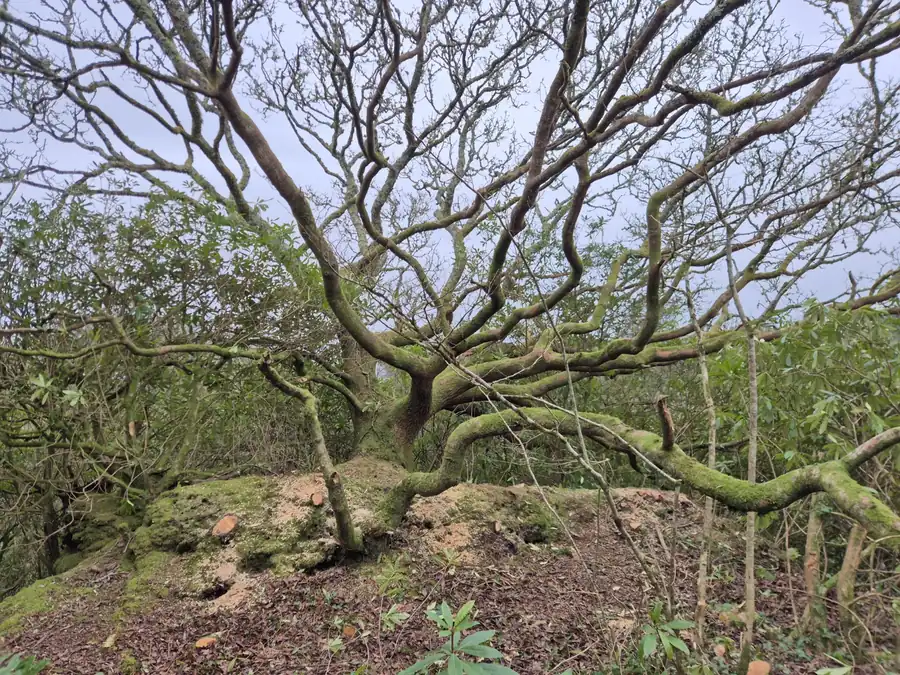
The oak on the remnant.
Between the front and back water, a raised teardrop-shaped remnant sits close to the level of the surrounding farmland - a surviving piece of the older ground within the excavation.
On its edge stands an oak around 200 years old, low-splitting and broad-crowned. Rhododendron has been cleared on the flatter side; the exposed slope will be opened more gradually.
It is one of a small number of older trees that pre-date the present woodland. Mature sweet chestnut, grey willow and laurel survive elsewhere on the site, alongside several very large beeches in the southern section, believed to be a few hundred years old.
The 1948 aerial shows that most of the woodland visible today had not yet established. Much of what now feels like mature woodland has grown since then, with many of the trees likely to be around fifty years old or younger.
Water routes and structures
Stone supports survive in the north-west of the site. Their exact purpose is unresolved, but their alignment suggests that water may once have been carried across the workings on a different route.
The southern stream is separate today. The old maps may yet explain how the two histories fit together.
Features under the woodland
Some mapped features have disappeared under decades of growth while others reappear during clearance. New finds are added to the site record as they turn up.